Friday, April 11, 2008
Finding Iran's long-range missile site in Google Earth
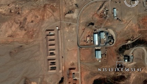
A secret site where Iran is suspected of developing long-range ballistic missiles can be explored on Google Earth. Entering the coordinates N 35 13 19, E 53 53 41 reveals a Digital Globe satellite image of the facility taken earlier than the one posted in today's Times story ("Spy photos reveal 'secret launch site' for Iran's long-range missiles," by Michael Evans). The Times story claims the more recent image was taken four days after the launch of Iran's Kavoshgar 1 "research rocket" on February 4.
According to Jane's Intelligence Review, the photograph is said to reveal to a former Iraqi weapons inspector that Iran is using the site, about 230km southeast of Tehran, to develop a ballistic missile with a range of 6,000 km. Geoffrey Forden, research associate at Massachusetts Institute of Technology, is quoted as pointing out that a recently constructed building, 40 meters in length, is similar in shape and size to the North Korean long-range Taepodong missile assembly facility.
The new building is plainly visible in the lower left corner of the photograph accompanying the Times story (below), and is notably absent on the earlier Digital Globe image currently in use on Google Earth.
According to Jane's Intelligence Review, the photograph is said to reveal to a former Iraqi weapons inspector that Iran is using the site, about 230km southeast of Tehran, to develop a ballistic missile with a range of 6,000 km. Geoffrey Forden, research associate at Massachusetts Institute of Technology, is quoted as pointing out that a recently constructed building, 40 meters in length, is similar in shape and size to the North Korean long-range Taepodong missile assembly facility.
The new building is plainly visible in the lower left corner of the photograph accompanying the Times story (below), and is notably absent on the earlier Digital Globe image currently in use on Google Earth.
UPDATE: You can also see the Google Map imagery without leaving your browser at Flash Earth
UPDATE 2
The original story from Jane's can be found here: Iran Develops Long Range Missile Technology:
Analysis by Jane's has identified several developments at this site since the most recent open source imagery was taken in September 2004. Jane's has identified facilities at this site similar in size and form to the Taepodong assembly facility in North Korea. Measurement and Signatures Intelligence by Jane's shows features of the site are also similar to North Korean facility features that indicate this facility is the location of missile assembly.(Hat tip:TheZoo)
Jane's Proliferation Editor Avital Johanan commented: "This analysis suggests that Tehran is following the same path in its missile programme as North Korea and identifies a previously unidentified location as an important element in it. Bringing together Jane's analysis with exclusive satellite imagery provides a unique capability to offer near-real time intelligence."
Labels: DPRK, Google Earth, Iran, Jane's Intelligence Review, long-range ballistic missiles, North Korea, Taepodong-2 missile


Thursday, September 23, 2004
North Korea About to Conduct Another Missile Test?
Yomiuri Shimbun has reported that Japanese and U.S. intelligence officials, using satellite images and other methods, have detected the movement of missile units in North Korea around multiple Rodong missile launch sites. [Korea Times: "Seoul Alert for Possible NK's Missile Test"]
The Defense Ministry of South Korea has sought to calm fears. Military spokesman Brig. General Nam Dae-youn suggested that the movements were a part of annual military exercises, but acknowledged that the possibility of a test-firing could not be ignored.
Japan has deployed an Aegis-guided destroyer and some intelligence planes, including the EP-3 to the East Sea between Japan and the Korean peninsula to monitor the situation. North Korea shocked Japan in 1998 by test-firing a missile across Japan and into the Pacific Ocean.
U.S. intelligence is particularly concerned about the possibility of a test of the Taepodong-2 missile. The Taepodong-2 is believed to be capable of striking targets within a range of 3700 miles, thus representing a potential threat to Alaska and Hawaii.
The Defense Ministry of South Korea has sought to calm fears. Military spokesman Brig. General Nam Dae-youn suggested that the movements were a part of annual military exercises, but acknowledged that the possibility of a test-firing could not be ignored.
Japan has deployed an Aegis-guided destroyer and some intelligence planes, including the EP-3 to the East Sea between Japan and the Korean peninsula to monitor the situation. North Korea shocked Japan in 1998 by test-firing a missile across Japan and into the Pacific Ocean.
U.S. intelligence is particularly concerned about the possibility of a test of the Taepodong-2 missile. The Taepodong-2 is believed to be capable of striking targets within a range of 3700 miles, thus representing a potential threat to Alaska and Hawaii.
Labels: DPRK, Japan, North Korea, South Korea, Taepodong-2 missile
main page
most recent entries
- The sting of 'cling'
- Finding Iran's long-range missile site in Google E...
- Southern Iraqi Shiite tribal leader claims Iran be...
- Rice for the Vice?
- A stash of FARC's uranium found in Columbia
- Is Condi Rice signaling an interest in being McCai...
- Saddam Hussein's regime plotted with Gaza terroris...
- An unapologetic apologia for the Iraq war
- Romanian rendezvous; Terrorists and arms dealers i...
- Saddam's support for terror: the Pentagon report's...
archives
blogs
feeds




searches
statistics
buttons
Blogroll Me!


